


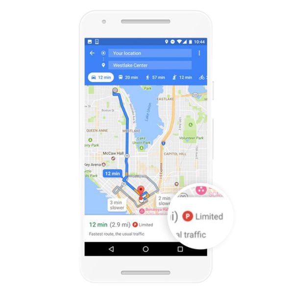
Google is adding a new feature to Google Maps for Android to help users plan their hunt for a parking space when arriving at a destination. The new feature will provide information on parking difficulty at a destination in 25 metro areas in the U.S. The information will be provided via an icon to help users assess whether they need to be ready to just pull up to their destination or if they may be circling the block for a while in search of a parking space.
The icon will appear at the bottom of the Google Maps screen in the directions card after you have entered your starting and ending locations. Google says the level of difficulty will be rated on a scale ranging from “limited” to “medium” to “easy.” The icon itself is a round circle with a letter P on it.
Apps like Google Maps or Google's own competing product Waze have been adding live traffic updates to help users anticipate travel times or even reroute to account for incidents in real-time. Adding in data on parking difficulty is consistent with this framework of trying to help users get where they want to be when they want to be there. A downside to the new feature though is that it is not based on live data. Instead, Google is using historical data, which they say is the same source for the “Popular Times and Visit Duration” data presented for some destinations. Still, the parking information should be helpful for users traveling to an area they may be unfamiliar with.
For now the new feature is rolling out to the following markets:
- San Francisco,
- Seattle,
- Miami,
- Atlanta,
- Boston,
- Charlotte,
- Chicago,
- Detroit,
- Los Angeles,
- Minneapolis/St. Paul,
- New York City,
- Orlando,
- Philadelphia,
- Pittsburgh,
- San Diego,
- St. Louis,
- Tampa,
- Washington, DC,
- Cleveland,
- Dallas/Fort Worth,
- Denver,
- Houston,
- Phoenix,
- Portland and
- Sacramento.
source: Google