


![]()
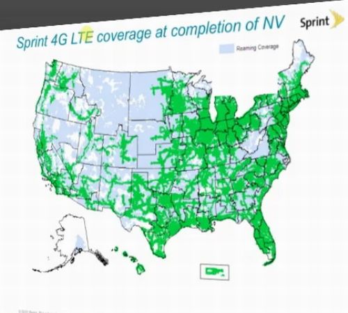
Well look what we have here folks. It's a map showing the plans of Sprint's 4G LTE Network for the year 2014. The map was posted on Twitter by tech journalist Sascha Segan. It appears to be legit, with questionable drawing skills as some of the states are not properly drawn. I know some maps are drawn up to represent market areas and are not always drawn to represent the States of the U.S. Whatever this case, it shows Sprint's determination to get 4G LTE out to the masses, no matter how small it seems to be. Jump past the break to see the map and read more.

The green shades represent the areas to receive 4G LTE by 2014, while the people in the blue are going to have to wait. This all seems good, but remember Verizon has a large portion of the U.S. covered and Sprint is playing catch-up. As the number three carrier in the U.S. Sprint has some major ground to cover to get back into direct competition with the likes of Verizon and AT&T. Only time will tell if Sprint's plan is solid or a little too late. With me being a Sprint customer, I do like seeing my little town of Fort Collins covered by the 2014 plan. I just wished I didn't have to wait until 2014 for it. What about you, are you happy to see your area covered, or are you left in the blue shaded area? Let us know in the comments section below.
Source: Twitter
![[Breaking] Newest Google Drive Screenshot Shows 5GB of Free Storage 4](https://www.talkandroid.com/wp-content/uploads/2012/03/drive_install-380x250.png)
Is it working in Loveland CO?? Oct 2014?
It’s 2014 and the map looks nothing like this. #epicfail
Sprint is HORRIBLE in Fort Collins, which despite this article is actually a medium sized city not a small town. They also have horrible customer service and don’t seem to be doing anything about it. If this continues I don’t see Sprint lasting 2 more years. I don’t know anyone who will be back after their contract.
Its in loveland and about to be in foco, blazing speeds in loveland as we speak, yes it is for the mot part horrible, and to not be in foco is crazy given the massive businesses that are here.
Sprints service is oregon is beyond terrible, don’t buy sprint !
I am so sick of sprints crappy 3g in Fort Collins. Everyone else has 4g and I’m going to leave spring for Verizon if they don’t make this happen.
2013 We got to get LTE
Sprint needs better service And The need Better Customer service And They need Those people Is Working On Those Towers Need to Work Faster Because Or reception Sucks And We need LTE Ardmore Oklahoma In about a month Because It Sucks Thank you
I agree. Sprints service in Fort Collins is so terrible. I never get more than one bar. They better get on the ball because I’m about to switch to Verizon.
I live in Ardmore Oklahoma And I have 3G Why do I not Have LTE My reception sucks I need LTE
I Live and Ardmore Oklahoma Why. Do Not Have LTE This year 2013
Sprint blaa I’m so tired of being told to wait for 4g time after time. They droped the ball if you ask me. Now I have to watch everyone I know play with there new 4g duel and quad core phones I plane on getting a samy galaxy s3 or new htc and I would mike a nice fast 4g network to run it on I don’t think sprint can provide that any more
I agree. Get on this, sprint.
I think the bigger question here is what in the hell happens in 2013 that there are now so many more states?
I have wifi at home and sprint 4g wired into the hospital that I work in. The two places I spend the most time I always have high speed internet. It may not be LTE but for now I am happy with Sprint.